For the last decade I have lived in the leafy London Suburb of Teddington. While Teddington's history dates back to Saxon times most of what is now modern Teddington was developed following the construction of Teddington Lock in 1811 and the railway in 1863. The close knit network of Victorian and Edwardian streets that forms the heart of modern Teddington was complete by the turn of the 20th century.
For those who know Teddington well there is a conspicuously large development of much more modern buildings between Somerset, Stanley, Church and Walpole roads. I had always assumed that these more modern buildings and spaces were a result of urban renewal during the 1960s, but it turns out that it had less to do with the plans of developers, and much more to do with the Luftwaffe during the Second World War.
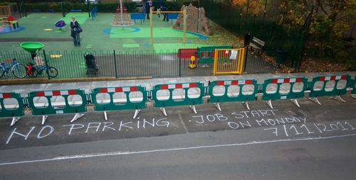 The council work in November 2011 that started it allMy interest in this oddly 'modern block' was piqued by a council road crew and a conversation with a neighbour. In November of 2011 Richmond Council removed a drop kerb from outside the playground on Church Road. While chatting about the work to a neighbour who had lived and worked in Teddington for the last 70 years he mentioned that the drop kerb had originally marked the entrance to a road that no longer exists. He went on to reminisce about playing on the bombed out houses that had stood on the site, homes that had been destroyed, not by a bomb dropped from a Luftwaffe bomber, but by a V1 flying bomb, Germany's first vengeance weapon and the world's first guided missile built by the Nazis at the end of the Second World War. After 68 years the council were removing the last visible traces of the road the Germans had destroyed in July 1944.
Teddington seemed to have suffered more than other suburban areas of London. While it was far from the industrial or agricultural heart of the UK it did have some high value targets. In Bushy Park, just 500 metres from Teddington station, the Americans built Camp Griffiss which was to serve as the European Headquarters of the US Army Air Corp, and as the war progressed the park also served as the Supreme Headquarters of the Allied Expeditionary Force as they planned the D-Day landings. The National Physical Laboratory on the perimeter of Bushy Park was involved in military aviation research and is where Barnes Wallace conducted tests for the bouncing bombs used in the bombing raids on the Möhne and Edersee Dams immortalised in the 1955 film Dambusters.
It wasn't until recently that I recalled this conversation with my neighbour. During a recent clear out of books I found an old London street Atlas and it contained a map showing Argyle Road in Teddington, a road that should be just opposite my front door yet I had never heard of before. The Atlas was printed in 1937 so Argyle road was clearly there before the war started and it's location matched the spot where the council had recently removed the old road entrance.
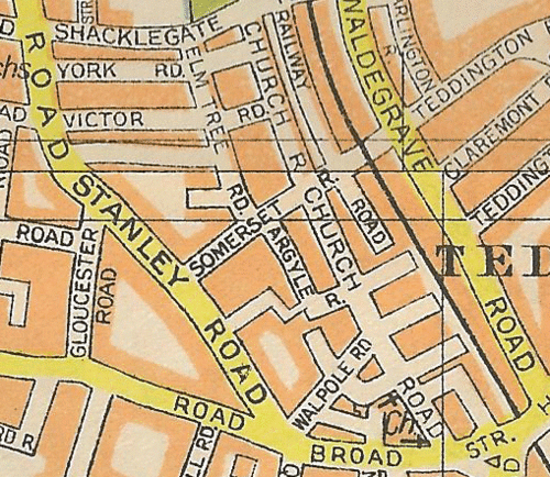 The streets surounding Church Road as they appeared in 1937
 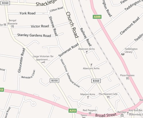 Church Road as it appears in 2012
While London suffered significant bomb damage in the early stages of the war the frequency of the attacks reduced as the war in Europe in expanded. As the war drew to a close the bombing attacks on the Capital started up again but now using the V1 'doodlebug' flying bomb and the V2 ballistic missile. In July 1944 one of those V1s flew over London on it's way towards Teddington. Given the rudimentary guidance system fitted to the V1 – the operators set a compass bearing and the time that the V1's pulse jet engine was to run for – it seems unlikely that Argyle Road the intended target, but Argyle Road is where it fell, and is where 40 people and an entire road met their end.
While the doodlebugs distinctive 'droning' pulse jet gave those on the ground some warning, the V2 fell to earth at such high speed that the first indication of a V2 was the sound of it exploding as it crashed back to earth. The only V2 that landed in Teddington exploded in Fairfax road in July 1944 (only a few hundred metres from the US Army Air Corp's Camp Griffiss) and led to the evacuation of 7,000 women and children from the local area.
It seems odd to me that I've lived so close to the location where over 40 people lost their lives and yet I knew so little about it. I wasn't brought up in London, or even the UK, but even my family has extremely close links to the UK during the war. (My grandfather was in the RAF and his cousin lost his life while serving in the London Fire Brigade during the Blitz). Since I re-discovered that 75 year old street Atlas I've been in contact with the National Archives in Kew with a view to looking at the Bomb Census to look at the details of the bombing activity in Teddington, and ultimately finding out more about the history of the street I have now lived on for over 10 year.


